
Best in Travel
The 30 best countries, cities and regions to visit in 2025

See where a Lonely Planet Membership takes you
Plan your trip with Elsewhere, by Lonely Planet
Book with our partner, GetYourGuide

Subscribe to our weekly newsletters to get the latest travel news, expert advice, and insider recommendations
Articles by interest

Every month, we release new books into the wild

Explore the world with our detailed, insightful guidebooks

Stay ahead of the curve with our guidebooks

Uncover exciting new ways to explore iconic destinations

Download instantly and read any time

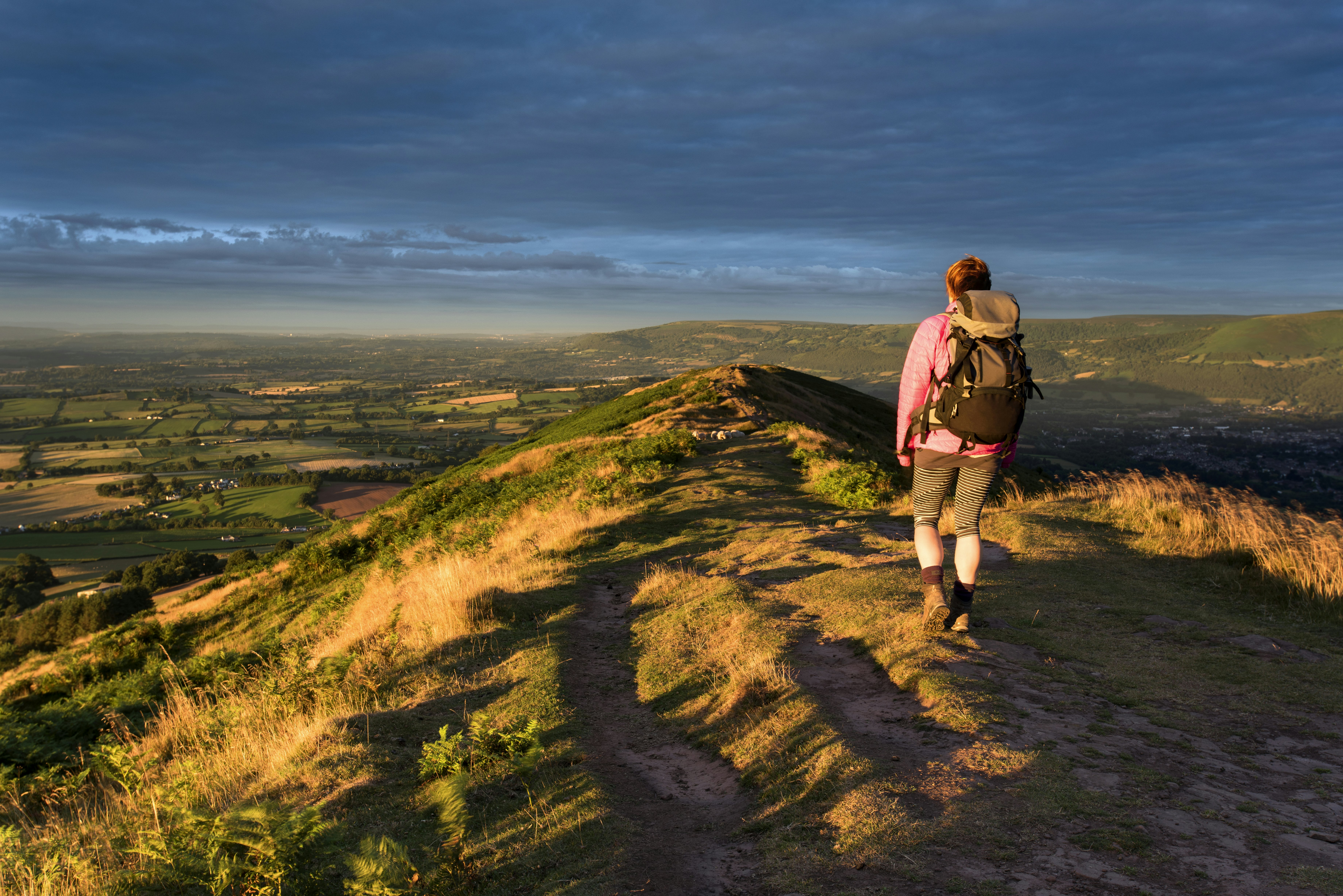
Hiking on the Llŷn Peninsula, Wales. Alan Morris/Getty Images
A hefty chunk of Wales is properly remote wilderness, so it’s easy to give the crowds a miss in this country of lonely moors and mountains, cliff-rimmed coastlines and tucked-away valleys. Time it right and you’ll mostly share the trails with nothing more than the odd unruly sheep or whistling red kite.
We’ve combed the length and breadth of Cymru to bring you the pick of the country’s best hikes – from Snowdon ascents to Pembrokeshire Coast Path jaunts, walks around lakes of legend to rambles through prehistory. Lace up your boots and brace yourself for the whims of the Welsh weather, as there is no better way to see this little-but-lovely land than on foot.

Best hike for fans of Welsh folklore
4-mile loop (6.5km), moderate, 2.5 hours
It might feel like the road to nowhere as you swing along the narrow, steep single-track lane lined with hedgerows. But eventually you will emerge to bleating sheep grazing grassy uplands and a delightfully remote parking lot in Llanddeusant, the trailhead for this spectacular 4-mile trail to Llyn y Fan Fach.
Out on its lonesome in the Black Mountain range in Bannau Brycheiniog National Park’s western reaches, Llyn y Fan Fach has a primeval, almost brutal, beauty to it. Glacier-eroded peaks rear above this steel-blue lake, the backdrop for the Lady of the Lake legend, which appears in the medieval Welsh folk epic, the Mabinogion. Follow the babbling river upstream to the lake, knife-edge ridge and upland moors beyond.
Local tip: Brush up on your mythology. As the story goes, in the mid-13th century a young farmer gazed into the lake's waters when a beautiful maiden emerged. He coaxed her ashore and begged her hand in marriage. Her fairy father agreed, warning that if he ever struck her three times she would return to the fairy world.

Best hike for discovering Wales’ ancient history
7.4 miles (12km), moderate-challenging, 4 hours one way
Prehistory is writ large on the 7-mile, west–east Golden Road trail that clambers along the spine of the wild, remote Preseli Hills in north Pembrokeshire. Sheep and wild ponies are more commonly glimpsed than fellow walkers on this hike. Part of a 5000-year-old trade route between Wessex and Ireland, it heads through rugged terrain where clouds cast shadows across the bare moors, bogs and tors.
These hills hide a sensational ancient landscape, liberally sprinkled with hill forts, standing stones and burial chambers. Lore has it that the bluestones of Stonehenge hail from here.
Tap into the region’s mysterious past on this half-day trek, taking in its stride Foel Eryr, topped by a Bronze Age burial cairn, Foel Cwmcerwyn, the highest point in the Preseli Hills at 1759ft (536m) and Bedd Arthur, an eye-shaped stone circle said to be King Arthur’s final resting place. At trail’s end, look out for so-called "singing stones" at Carn Meini, which chime when struck with a hammer and have the same sonorific qualities as those at Stonehenge.
Planning tip: The trail begins at Bwlch Gwynt is on the B4329. Take care with navigation as the path is well trodden but not waymarked (the route is less visible in rain or fog).
Best hike for borderland views
4 miles (6.4km), easy-moderate, 2 hours
There are far higher peaks in Wales, but there’s something special about Skirrid (Ysgyryd Fawr), a knobbly, 1594ft (486m) ridge of rock, standing in isolation on the eastern cusp of the Black Mountains not far from the English border. Shaped by glaciers during the last Ice Age, Skirrid is nicknamed the "Holy Mountain", with local legend recounting how a massive landslide on its northern flank was caused by an earthquake or lightning when Jesus was crucified.
With arresting views in all directions, this invigorating circular stomp is doable even for energetic families. Starting and ending at the National Trust car park on the B452, the path heads uphill through ancient, fern-flecked broadleaf forest, hazed with bluebells in spring. As you pass through a gate in a drystone wall and contour the hill, keep an eye out for the ruins of an Iron Age hillfort.
Take a deep breath for the final climb to the trig point-topped summit, passing the medieval remains of St Michael’s Chapel en route. On cloudless days, the views are phenomenal, taking in the neighboring pinnacle of Sugar Loaf and reaching over chequered hills west to the Brecon Beacons and south to the Severn Estuary. Head south down the ridge, then retrace your steps through woodland.
Local tip: The wind-beaten summit is an exhilarating lookout. Gaze up as well as out to see buzzards, kites and kestrels wheeling on the breeze.

Best hike for beach lovers
3 miles (4.8km), easy, 45 minutes
A spirit-lifting expanse of sky, sand and pounding surf awaits at Ynyslas in Ceredigion, where rippling dunes form an integral part of the Dyfi UNESCO Biosphere Reserve. This nature reserve draws wetland birds such as ringed plovers and shelducks, as well as dolphins, porpoises and otters. Boardwalks thread through the dunes, which are brushed with breeze-bent marram grass and, in summer, freckled with wildflowers like marsh and bee orchids and sea pink. It’s a tranquil place to wander down to the wide, long, shell-strewn beach, with the dark peaks of Snowdonia glowering in the distance.
Walk a 3-mile (one way) stretch of the Ceredigion Coast Path to Borth, where very low tide reveals the petrified tree stumps of a prehistoric pine, birch, elder and oak forest, submerged over 6000 years ago. Look out, too, for ancient human and animal footprints now fossilized in the hardened peat surface.
Planning tip: In winter, Snowdonia’s snow-dusted peaks on the horizon give the coast here added drama, but the wind and waves can be wicked. Spring and summer are best for birdwatching and wildflowers.

Best hike for epic mountain views
6 miles (9.7km) round trip, challenging, 5 hours
Snowdon has the height edge, but for equally phenomenal views and far fewer crowds, opt instead for the challenging ramble up to 2930ft (893m) Cadair Idris. Bang in the heart of Eryri (Snowdonia) National Park, this hulking, sheer-flanked, gold-green crag looks like a figment of Tolkien’s imagination. It’s a mountain of myth too, named after a 7th-century giant called Idris. Sleep on its slopes and, legend has it, you will awaken either mad or a poet.
There are several ways to climb it, but the tough, 6-mile, heart-racingly steep Minffordd Path clambering up the southern slopes is arguably the most dramatic. The real bonus is getting to stop off for a shockingly cold wild swim at Llyn Cau, a glacial cirque lake rimmed by ragged 1312ft-high mountain walls.
Planning tip: Best hiked in spring and early autumn to dodge the crowds and worst weather, this circular walk begins and ends at Dôl Idris car park. Check conditions before heading out. OS Explorer map OL23 (Cader Idris and Llyn Tegid) is handy for navigation.
Best hike for families
2.5 miles (4km), easy, 1 hour
Barren, sparsely populated and often utterly silent but for the piercing whistle of red kites wheeling overhead, the Cambrian Mountains are Mid-Wales at its wildest, starkest and off-the-radar best. In fact, they're perfect for a bandit seeking a hideaway, such as Twm Siôn Cati, a 16th-century outlaw of Robin Hood–like status.
The 2.5-mile circular walk at RSPB Gwenffrwd-Dinas reserve takes you deep into ancient, lichen-draped oak and alder woods, which are misted with bluebells and filled with the echoing call of cuckoos in late spring. The rugged, tree root-strewn trail twists along the banks of the fast-flowing Nant Ffin and deep into a boulder-strewn valley. Steps twist steeply up to Twm Siôn Cati’s lair at roughly the halfway point. Scramble into the cave to see elaborately etched graffiti, some dating to Victorian times.
As you wander, keep an eye on the sky. This conservation area is rich in birdlife and you might well spot pied flycatchers, grey wagtails, wood warblers and tree pipits, red kites, buzzards and peregrine falcons.
Planning tip: Bring sturdy boots as the rocky path can get very slippery when wet. In summer, the banks of the river are a beautiful spot for a picnic.

Best hike for sea views and dolphin spotting
3 miles (4.8km), moderate, 2 hours
Pembrokeshire is rightly celebrated for its castaway beaches, high cliff tops and magnificent 186-mile (299km) coast path. But if you have neither the time nor the stamina for the full coastal shebang, try one of the most memorable short hikes loops around the headland of Dinas Island.
Dodge the high season and you’ll have the 3-mile circular trail largely to yourself. Fringed by jagged, gorse-clad cliffs, the coast is imprinted with smugglers’ coves bearing the full brunt of the Irish Sea. Most are only accessible by boat, so content yourself with the views from Dinas Head (where dolphins and seals can sometimes be spotted) and Needle Point (occasional puffin sightings). In the hamlet of Cwm-yr-Eglwys, you’ll find the ruins of medieval St Brynach’s Church.
Local tip: Round out your walk with a pint, ice cream or fish and chip lunch at the Old Sailors at Dinas Cross. Snag a picnic table outside for views across Pwllgwaelod Beach.
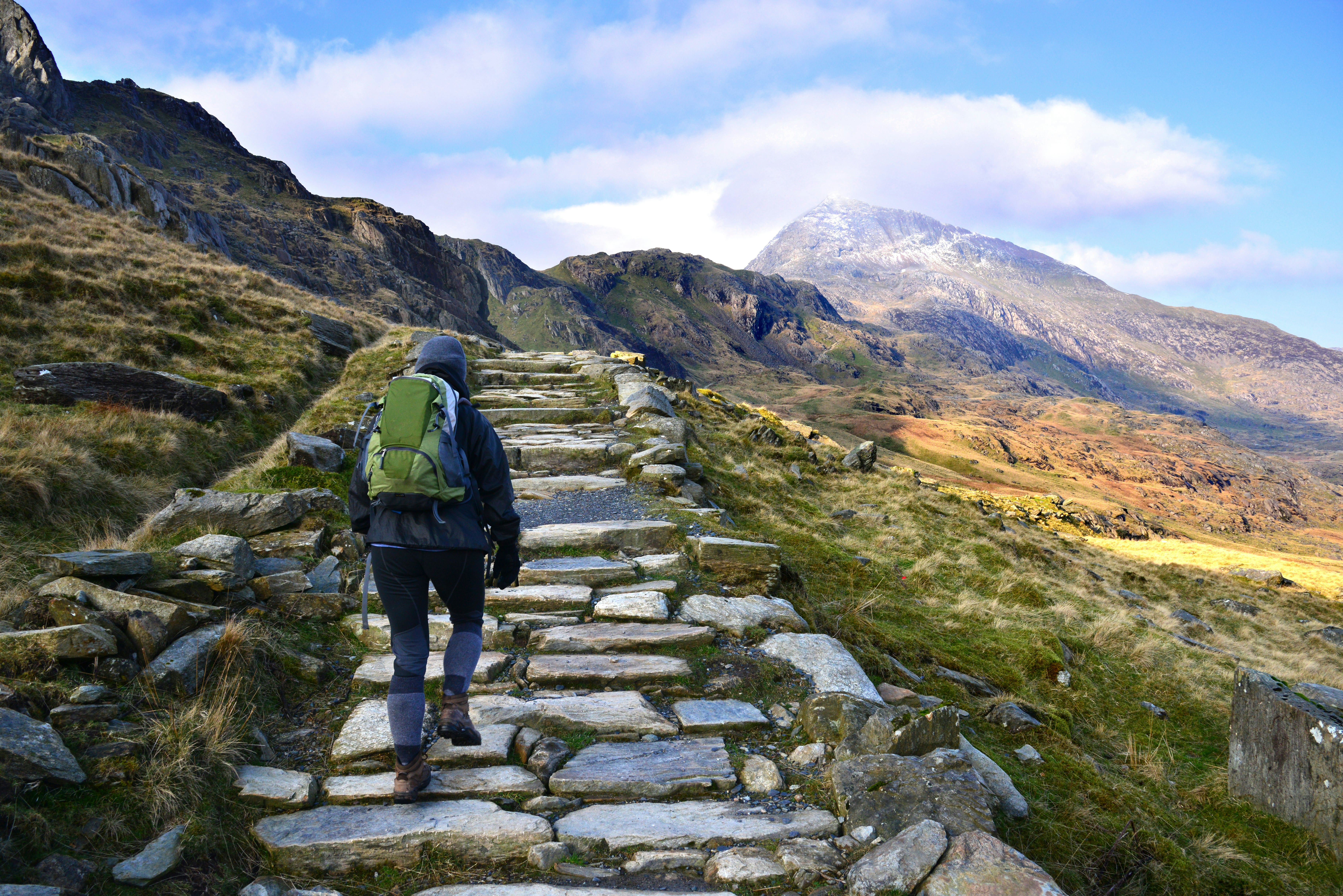
Best hike for stirring summit views
7.5 miles (12km), challenging, 6 hours
No matter which route you take, puffing up to the summit of Wales' highest mountain, 3560ft (1085m) Yr Wyddfa (Snowdon) is no walk in the park. Don’t be fooled by the fact there is a railway trundling to the top or its popularity, with a stampede of 600,000 hikers clambering up here every year. Do it right and this trek remains one of Wales’ greatest challenges – breathtaking in every sense of the word.
Give the crowds on the well-trodden Llanberis Path the slip, instead opting for the 6-hour, out-and-back Rhyd-Ddu Path, which is more peaceful. The trail ascends the western slopes of the mountain, following an old slate quarry track before climbing steeply over rocky terrain and making the final push to the summit. At the top, the sweat and blisters are worth it – on a clear day, views are out of this world, reaching all the way to Ireland and the Isle of Man.
Planning tip: You need a good level of fitness and navigation skills for this one. The trail can be narrow, steep and exposed (as well as icy in winter). Come prepared for rough terrain and fickle weather.

Best hike for 360-degree panoramas
2.7 miles (4.3km), moderate, 2 hours
The wondrously wild Llŷn Peninsula is where Cardigan Bay slings its northern hook into the Irish Sea. The rumpled massif of Snowdonia puckers up to the east, while Ireland is but a pebble’s throw west across the wave-tormented sea.
For uplifting views, strike out on the 2-hour, 2.7-mile circular trail to Mynydd Rhiw. Though modest in height, this 997ft-high (304m) lump of ancient rock has a pinch of everything that makes the peninsula special. Beginning at the Plas-yn-Rhiw car park, the path clambers up and over sheep fields, dry-stone walls and heather-brushed moors to the ridge-top trig point. From here, there are spirit-lifting views of Snowdonia, the great golden arc of Porth Neigwl (Hell's Mouth) and offshore Bardsey Island, where 20,000 saints are said to lie buried. Keep an eye out for Neolithic axe factories on the descent.
Local tip: Don’t rush straight off. Factor in time for a visit to Plas-yn-Rhiw, a beautifully restored 17th-century manor house immersed in ornamental gardens. The tea room whips up a Welsh cream tea that’s perfect post hike.

Best for long-distance ramblers
99-mile (159 km), moderate-challenging, 8 days
You can get a taste of what’s out there on a day hike, but for a deep dive into the wild, rugged, forgotten beauty of Bannau Brycheiniog National Park, chuck on boots to tackle the multiday Beacons Way. Striding across the national park, this 8-day trek is a proper challenge, kicking off at Ysgyryd Fawr (Skirrid) near Abergavenny in the east and marching up and over hill to Bethlehem in the west. Going off the beaten track, the path scrambles over high moors, up bald summits and through glacier-scoured valleys.
This hike rewards you with plenty of scenic and historic highs: from Llanthony Priory and Crickhowell’s Iron Age fort-topped Crug Hywel (Table Mountain) to Pen-y-Fan, Llyn y Fan Fach and the romantic medieval ruins of Carreg Cennen castle. Hit the trail in summer for longer, lighter days and more stable weather. By night, the skies twinkle with an eternity of stars in this International Dark Sky Reserve.
Planning tip: For full route details, pick up a copy of the Beacons Way booklet. OS Explorer maps OL12 and OL13 cover the hike in detail. You'll need to be fit, surefooted and know how to read a map and compass, as way-marking can be patchy. There are B&Bs, campsites, hotels and bunkhouses at the end of each day’s walk, but accommodation is more scarce in the west of the park, so plan ahead.

Best hike for romantics
3.5 miles (5.6km), easy, 2 hours
If ever you’re going to fall head-over-heels in love with the beauty of Wales, it will surely be at Ynys Llanddwyn, a small tidal island off the west coast of Anglesey (Ynys Môn), with its wide-open skies, shifting sands and painterly light.
Beginning at the Newborough Forest parking lot, this 3.5-mile circular walk delves into shady Corsican pine woods where red squirrels scamper, emerging at one of the island’s loveliest dune-flanked beaches, and crossing over to Llanddwyn, a rocky spit of land that becomes an island when cut off at very high tide. Here the ruined chapel of St Dwynwen's stands on the site of a Celtic nunnery. Pilgrims have been drawn here for centuries because of their connection to St Dwynwen, Wales’ patron saint of lovers (a Welsh St Valentine of sorts).
Planning tip: Check weather conditions and tide times before heading out, as the island gets cut off at high tide when the path becomes submerged.

Best hike for dramatic coastlines
5 miles (7.9km), moderate, 3 hours
If you have time for just one short-but-sweet walk on the epic, 186-mile (299km) Pembrokeshire Coast Path make it this circular beauty, which begins and ends on the surf-smashed, mile-long shores of Whitesands Bay in St Davids.
In summer, St Davids, Britain’s smallest city and birthplace of Wales’ patron saint, becomes a full-on coastal honeypot, heaving with visitors admiring its gigantic medieval cathedral. You can quickly give them the slip on this half-day hike, which heads up and over stile and through the kissing gate to St Davids Head.
Fortified by the Celts, the gorse-draped promontory is a remarkable place for a coastal romp, packing in towering sea cliffs, deliciously hidden coves like Porthmelgan where you can stop to paddle (beware of strong currents), captivating views across the sea to Ramsey Island, an Iron Age hill fort and a Neolithic burial chamber.
Local tip: The headland attracts lots of wildlife. Look out for wild ponies on the grasslands, peregrine falcons, kestrels and choughs in the sky, porpoises out at sea and, from late August to November, seal pups on secluded beaches.

Planning on tackling a few hikes in one trip? Plan your pit stops in advance. Wild camping is illegal in Wales unless you have the express permission of the landowner.
Popular mountains, including Snowdon and Pen-y-Fan, get extremely busy in the summer months (we’re talking lines leading up to the summit). Aim to travel in off-season or choose alternative peaks.
Wales is known for its rain, but it pays to be prepared for all conditions, as weather can be unpredictable and changeable. Pack sunscreen, a raincoat and plenty of layers.
The mountains aren’t the only place to find steep, thigh-burning walks. The 870-mile (1400km) Wales Coast Path (the world’s first to follow a country’s entire coastline) is plenty hilly too. Completing the Pembrokeshire section alone is said to equate to summiting Mt Everest, with 35,000ft of ascents and descents.
Plan with a local

